The calendar tells us it’s autumn, but late summer still lingers. Although a few leaves scuttle crisp and yellow across the blacktop or silently drift on the gentle wind into pastures where the dark and sullen shapes of cows step through the sunrise mist to drink from still ponds, the green fullness of the trees remains. I have felt the chill in my toes and fingers and nose and at these early hours have stepped back inside for a light jacket but I am yet to see my breath on the air or a frost on the grass. It is, after all, just now late September in Tennessee.
Late summer fields in unincorporated Kedron.
License plates hanging in a Franklin shop.
A tree growing out of an old silo in Pelham.
Rocking chairs on a porch in Leiper’s Fork.
Maury County Courthouse in downtown Columbia.
A modular and a cow in Pelham.
Leaves in Burns Branch on the Natchez Trace Parkway.
Old car in a junkyard in Franklin.
A barn in Leiper’s Fork.
Mule Day banner hanging at Puckett’s Grocery in Columbia.
Photographs from this article, along with many others, can be found on my Instagram and Twitter. Follow me @highwayandhome
Words and photographs by author unless otherwise specified. All rights reserved.
Train Car. Cowan, Tennessee. Situated along the Nashville, Chattanooga & St. Louis Railway, Cowan is the last stop before the climb up the Cumberland Plateau. Downtown, they’ve re-purposed the old depot, making it into a railroad museum. This is one of the cars on display. (Photo and words by author.)
Old Buildings. Burwood, Tennessee. I don’t know what draws me to these kinds of places, but I pull over for them all the time. I imagine what antique thing might have been stored and forgotten inside. I imagine people from an older time shooting baskets at the old goal on the shed, their feet raising dust as they play. There is a new station there now, across the street, so whatever use the old pump once got is gone. Today, it’s just a relic sitting out in the sun. (Photo and words by author)
John Muir was onto something. Okay, perhaps many things. In An Ascent of Mount Rainer, he wrote that, “The view we enjoyed from the summit could hardly be surpassed in sublimity and grandeur; but one feels far from home so high in the sky, so much so that one is inclined to guess that, apart from the acquisition of knowledge and the exhilaration of climbing, more pleasure is to be found at the foot of the mountains than on their tops. Doubly happy, however, is the man to whom lofty mountain tops are within reach, for the lights that shine there illumine all that lies below.”
He knew what all those that enjoy the mountains know – that a mountain must be viewed from both the top and the bottom. It is this conclusion that informs the following photographs. They are all part of the same series of Smoky Mountain photographs that are included in my most recent Examiner.com article “Southeastern byways: US-441 through the Smoky Mountains,” and while some of them were indeed taken from US-441 – a route takes you to the highest mountain tops – others were taken at the bottoms and on the hillsides.
If you enjoy what you see here, click the link above, or visit my Examiner.com author page and click SUBSCRIBE to receive email updates when I post new articles and photography there. You can also follow me here, at my blog Between the Highway and Home.
Paling ridges. (North Carolina side of the Tennessee line)
Fog in the trees.
Dog in the doorway (The Look Shop, 2019 Goose Gap Road, Sevierville, TN)
Farmland has always held a special allure for me. I don’t know if I could say exactly why. I didn’t grow up on a farm. We had no barns, silos, livestock, pastures or crops. Yet the tranquility and remoteness of long, tilled fields, the earthy odor of horses or cows in the breeze, the sight of old machinery in an old wooden barn – these things bring to my heart a sense of nostalgia and longing nonetheless. Perhaps not for any part of my own life now lost to me but rather for a part of all our lives slowly becoming lost to all of us. Our country is increasingly entering into a post-industrial, post-urbanized phase where working the land has long since been a vanishing vocation. And I am not here to preach that this is a bad thing. But I am here to mourn the fact that farming as a way of life is fading. Small, rural communities centered around the crossroads feed and grain store are nearly gone. Fewer and fewer old men sit around discussing weather and crops over coffee. So, one day, after all the tractors are operated via satellite and the last barn crumbles to the earth, I’ll be that old man that sits back and says, “I remember when . . .”
A Pasture Gate in the Morning. This photograph was taken up near the Georgia-Tennessee state line, near Tennga, Georgia. I did not realize at the time that the rutted, gravel road that I had taken to this location took me across the state line. The pasture in the foreground is in Tennessee, the hills in the background are in Georgia.
Farm in Polk County, Tennessee. The rain that morning was patchy and struggling to break up over the mountains. The barn and pastureland pictured here lies just off US-411, at the foot of the Unicoi Mountains that make up the Tennessee-North Carolina border.
Farm in the Valley. Further northeast, at the edge of the Great Smoky Mountains National Park, this valley in Blount County, Tennessee, sits nestled into the folds of high ridges. Access to these remote locations has drastically improved in the last several decades, yet in truth it was not that long ago that places like this were somewhat isolated from the rest of the world. Travel has historically been difficult in Appalachia, and change slow to come.
Barn Quilt in Townsend. Many barns, like this one, are ornamented with what is called a barn quilt. Yet these “quilts” are not stitched cloth, but square pieces of wood painted with geometric, quilt-like patterns that are found all over the United States east of the Mississippi. Often times these patterns are symbolic or commemorative, with meanings peculiar to their owners, while others are simply artistic expressions.
Bluegrass in the Winter. Stanford, Kentucky is located in the Outer Bluegrass, on the perimeter of a region that is often considered to be one of the richest grasslands in the country. Nutrient rich grasses grow thanks to limestone-filtered water that percolates up through the ground. This water has been good for both the horse and bourbon whiskey industries, two of Kentucky’s most prolific exports.
Barn Quilts in Mercer County, Kentucky. This barn, located off of the Louisville Road just north of Harrodsburg, displays two barn quilts. These barns are used to smoke and dry one of Kentucky’s other most prolific exports: tobacco. Generally speaking, agriculture has been and continues to be the mainstay of the state’s economic and social life.
Indiana Field in the Afternoon. This Southern Indiana farm, located in rural Palmyra, is typical of the long hay fields of the region. Taken in winter, this photograph shows the field without the tall hay that will later grow and be harvested by large combines. Various farm equipage sits about the field, some of which has likely been in service on the farm for decades.
The photographs in this collection were taken by the author over a two day period in February 2015, on a road trip from the Georgia Piedmont to Southern Indiana.
The Tennessee Trails and Byways tourism department calls US-70 and US-70N between Nashville and Crab Orchard “the Promised Land: Pilgrimage to Presidents Trail.” It is so called because the region, known to some as the Upper Cumberland, was the first route into Middle Tennessee for American settlers, and later would be the home place of United States president Andrew Jackson. Much of the middle part of the state’s early settlement happened here, as well as what remains of those Indians who came before.
We left Mt. Juliet on a chilly but sunny January morning, just to see what there was to see and do and find. It would be nine hours before we returned.
Only open from Easter on through Christmas – and thus, no ham for us – the wonky roadside Rice’s Country Hams once served as Mt. Juliet’s country store. Today, US-70 is a busy metro-Nashville to suburban-Mt. Juliet thoroughfare, and in 1933 when the store opened, I doubt in Mr. Rice’s wildest dreams did he foresee a big box supermarket opening just a few blocks down and a Speedway being built just across the street that will, under its heat lamps, sell saran-wrapped ham sandwiches.
Spring Creek flowing through the Sellars Farm State Archeological Site on toward the Cumberland River. The archeological site was once a Native American village that is thought to have been long gone by the time Hernando de Soto explored what would become the American southeast in 1539-1540. Although de Soto is not believed to have reached this site specifically, the natives who lived here were part of a larger mound-building group called the Mississippian Culture.
Abandoned house on Sparta Pike just outside of Lebanon. Many such houses as well as barns line these rural routes on either side. Some are owned, others are not. And while there is a strong historical preservation culture in Tennessee, not all old buildings can be restored and up-kept. Many, like this one, will eventually disappear.
Downtown Watertown.
Storefront of Damn Fine Candy in Watertown. I strongly recommend purchasing a box of toffee. (You can visit Damn Fine Candy yourself at their website www.walkercreektoffee.com or by visiting their store at 114 West Main Street, Watertown, TN 37184).
Just after the little wayside hamlet of Dowelltown in DeKalb County, US-70 begins to climb up into the Cumberland Plateau, one of Appalachia’s least famed or celebrated regions where the soil is thin and rocky and deeply cut through with ravines, ridges and hollows.
A lone fisherman on a dock at the Center Hill Lake Ragland Bottom Recreation Area. Even in winter, the parking lot is filled with trucks hitched with boat-trailers. For many, fishing is not just a hobby, but a way of life.
We almost drove right past the Lester Flatt memorial in downtown Sparta. It turned out to be one of the unexpected treasures of the drive. Lester Flatt was one half of the famous bluegrass duo Flatt & Scruggs, who, second only to Bill Monroe, were the pioneers of the genre. After seeing the monument, we turned back around to see his nondescript grave just off the highway before continuing on.
An overlook off of US-70 east of Sparta with the Calfkiller River watershed below. Unlike traveling through the Great Smoky Mountains or the Blue Ridge Parkway, the Cumberland Plateau is a portion of Appalachia that has not been turned into a tourist destination. Therefore, roadside vistas like the one above are rare.
At Crossville, we took 70N to turn around and head back toward Mt. Juliet. This road was once called Avery’s Trace, a road blazed by a man of the same name who was commissioned in 1787 by the state of North Carolina (in which the current state of Tennessee was then a part of) to blaze a trail from the Clinch Mountains all the way to the remote settlements of the Upper Cumberland region. Just east of Cookeville (locally pronounced “Coo-v’lle”) we passed the Dry Valley farm pictured above and below.
Shortly after shooting these barns, the sun dropped low and then set completely. Tired from a long day’s drive and unable to see the 70N roadside anyway, we reluctantly turned on to I-40 and bawled back to Mt. Juliet. When we pulled back in my brother’s driveway, it had been nine full hours since we had left.
For more travel stories and photography from Between the Highway and Home, visit the homepage.
2014 was the year I began documenting the world with a camera. It was also the year that I began this blog. As the year ticked on, I began to realize that I accumulated a lot more shots than I could ever include here. So that’s what this post is about. The photographs included here didn’t make the cut the first time around, perhaps because they went under appreciated or didn’t fit a theme. Maybe they were just too random. Either way, here are my favorite unpublished photographs of 2014.
The front porch of an antique shop near Townsend, in Blount County, Tennessee. There are a great many of such shops in the area, with goods ranging from pure junk to rare gems. Often, the hard part is discerning between the two.
A southwesterly view of the Great Smoky Mountains National Park from the Foothills Parkway in Blount County, Tennessee. A faint sliver of Chilhowee Lake can be seen down in the valley. More of my photographs taken in the Smoky Mountains and East Tennessee can be seen here.
Cowboys on the gates at the Franklin Rodeo. The rodeo comes to Franklin, Tennessee each spring. This was my second year attending.
A pier and jetty sticking out into the Gulf of Mexico at Bay St. Louis, Mississippi. Crabbers and fishermen debark from here in the morning, returning later with the day’s catch. This photograph is one of a series, more of which were included in a previous post, which can be visited here.
Private boats moored at Pass Christian Harbor on the Mississippi Gulf Coast. The people of the area are indelibly tied to the water, whether for a living or purely for recreation.
The grave of Margaret Mitchell, author of Gone With the Wind, in Atlanta’s historic Oakland Cemetery. Without a doubt, her novel and the subsequent movie have done more to define the antebellum south for Americans, especially southerners, than facts ever have.
Several other grave sites at Oakland Cemetery with part of the city skyline in the background. The cemetery is sited on a ridge overlooking downtown and interred there are a vast array of people from the famous to the paupers.
An bluegrass string band thanks the crowd at Sims Opry House in Granite Falls, North Carolina. Another picture from Sims can be seen in an earlier photographic post entitled Southeastern Byways, Part 2, which you can see here.
An old car rusts in the sweltering summer humidity of Middle Tennessee. A private collector agreed to let us stroll around his property and take a look at the several hundred vehicles he has collected in his long life.
One among many of the long rows of rusting vehicles. It is hard to convey the size and scope of the collection he had. Most of them did not run, but those that did were worth a large fortune and were highly sought after by collectors.
Just three more of the many hundreds of old vehicles that were collected on the lot. The scrap metal on his place alone was worth a considerable amount.
A flower grows up out of the old No. 2 Franklin Fire Department truck that now sits back in the holler, one among many such historic vehicles in the collection.
Headstones and bouquets at one of America’s most unique cemeteries: the Key Underwood Coon Dog Memorial Graveyard in rural Colbert County, Alabama. In existence since 1937, there are now over 300 dogs buried here.
An easterly view of the South Carolina piedmont from high up on US-107 in Oconee County, South Carolina. Most people do not think about the Appalachian Mountains when they think of South Carolina, but none the less, the westernmost portion of the state contains within it part of the Blue Ridge Mountains.
A view of the mountain ranges to the south from Wears Valley Road, halfway between Pigeon Forge and Townsend, Tennessee.Late fall leaves floating on the Little River, just inside the Great Smoky Mountain National Park.Water moving over stones in the Little River in Blount County, Tennessee.Horses grazing near the mouth of Cades Cove Loop Road with the mountains that make up the Tennessee/North Carolina border beyond.An old Methodist Church in Cades Cove, Tennessee.A view of the mountains to the east from deep inside Cades Cove.A doe steps through the grass in Cades Cove.
Situated between Nashville, Tennessee and Natchez, Mississippi lies a 444 mile long National Park that affords its visitors a break from the modern world. But you don’t have to travel the entire length of it to enjoy what it has to offer. Pick any spot along the Trace and you can easily make a one day road trip out of any section. And for Nashvillians, what is arguably the most scenic section of the Trace, the Highland Rim Section, is right down the road.
The bridge over Birdsong Hollow as seen from the north end.
~
Nashville may not be the most urban atmosphere in the southeast, but life in any city can tend toward the monotonous. It isn’t long before I begin to feel cooked-up by the city, stricken by a weird sort of cabin fever. Sometimes I just need to get out in the country for a little fresh air and some wide-open spaces. Middle Tennessee is filled right up with places to satisfy this need, including the northern terminus of one of America’s most unique roads and National Parks: The Natchez Trace Parkway.
Even before this part of the country was settled by humans, the Trace is thought to have been pioneered by prehistoric mastodons and bison. And while the modern Trace does not exactly follow the original route, among the many that have gone before you on this fabled highway are prehistoric hunters, Chickasaw and Choctaw Indians, legendary Spanish conquistador Hernando de Soto, American frontiersmen such as Meriwether Lewis, Andrew Jackson, Davy Crockett an perhaps even Abraham Lincoln. The modern route through Tennessee’s Highland Rim Section, like the Old Trace before it, keeps to the ridges as much as possible. Originally, this was so early travelers could keep from the continuous ups-and-downs of the hills, as well as keep an eye out for and easily defend against any danger. And while of course travel in this region has gotten much safer, this high route produced an unforeseen advantage to the modern traveler: it affords great views of the surrounding countryside.
On the Trace, the hand of man is in as little evidence as possible and still be a paved road. There are no gas stations, no street lights, no billboards, no stores or restaurants and no eighteen wheelers. Throughout the entire Highland Rim Section of the Trace, you do not pass directly through a single town. Mostly the road winds through miles of wooded hills and river bridges, interspersed here and there with historical sites and nature trails. By the light of early morning or near sundown, you are liable to see turkey, deer and coyotes. By day you’ll see Harley-Davidsons roaring up the trace from Alabama and Mississippi or riders on horseback out on the trails.
What follows is by no means a comprehensive list of things to do and see on the Trace, but a handful of highlights to hit while traveling the comparatively short Highland Rim Section. The route outlined here amounts to a mere 120 miles round trip, which would take just over two and a half hours straight through. But you should take your time on the Trace, make stops and talk to everyone you meet. This road isn’t about the destination. That’s what the interstate is for. The Natchez Trace Parkway is the destination. Anywhere on it and you have already arrived.
What to bring: First, you should have a full tank of gas and bring a picnic lunch or some snacks before you get on the Trace. You will have to exit the Trace to fill up your tank and belly, and in some spans, exits to towns are tens of miles apart. Second, leave the boat shoes, flip-flips and stilettos at home in favor of something sturdier that you don’t mind getting a little dirty. The trails aren’t particularly strenuous hikes, but it’s no shopping mall either. Third, bring a camera and binoculars. There are plenty of scenic vistas and great photo opportunities lining the route. You won’t regret the extra weight. Fourth, bring a little drinking water along with you, especially in the summer. You’ll notice a lack of vending machines in a hurry if you don’t.
The Loveless Café along Highway 100 (photo credit: Justin Saucier).
The Loveless Café, Highway 100: If you get going early in the morning, be sure to start your day at the famous Loveless Café on Highway 100, just east of the northern terminus of the Trace. But get there right when they open (7am, daily) or expect to wait for a table. They get busy in a hurry and you don’t want to cut into your Trace time. The Loveless Café is known for its fried chicken and biscuits and many of its recipes date back to its 1950s origins. After breakfast, just hop back on Highway 100 and head west. You’ll see the northern terminus of the Trace almost immediately.
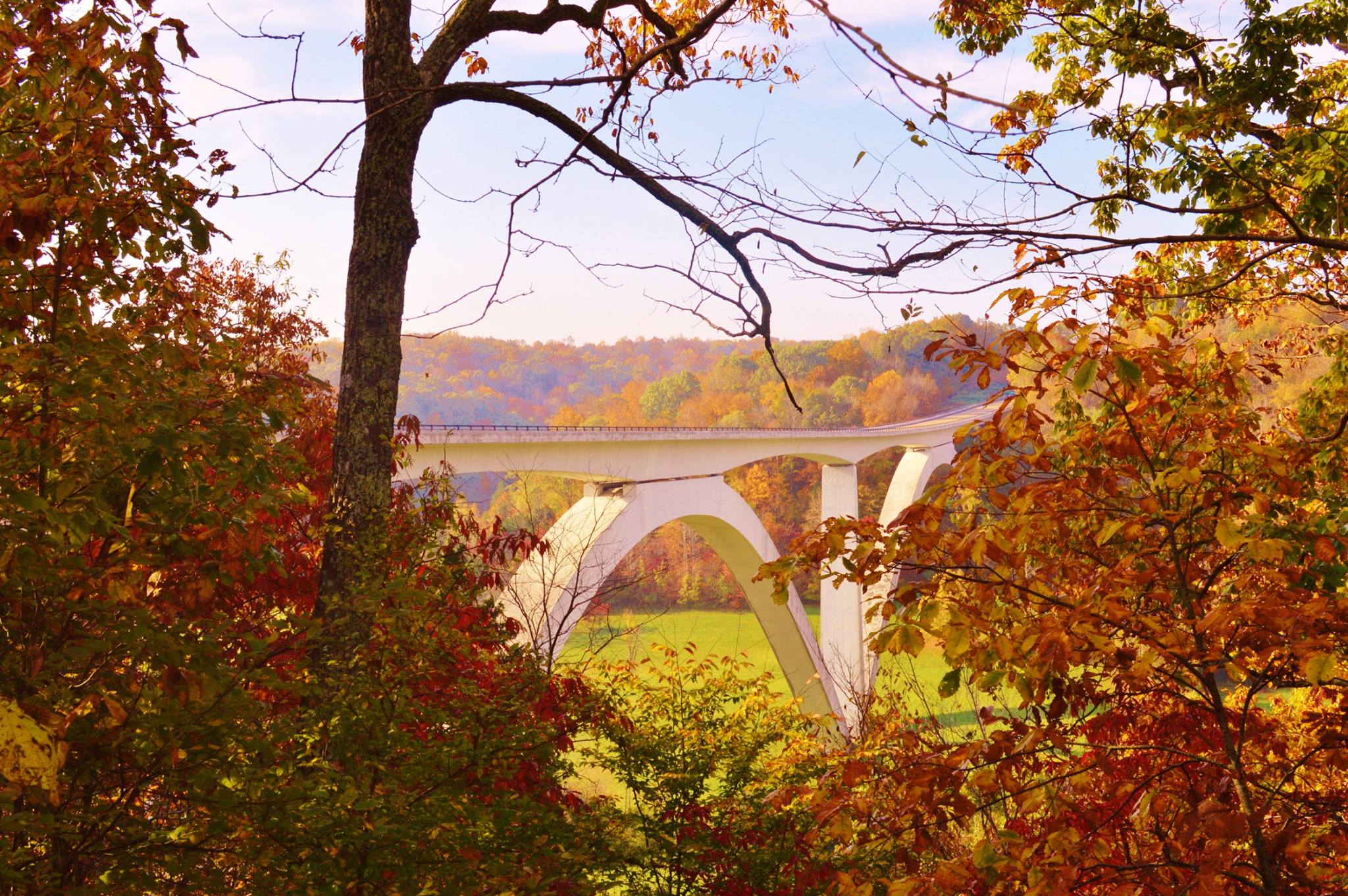
The bridge over Birdsong Hollow as seen from Highway 96.
Birdsong Hollow, milepost 438: Just a few miles after starting out, you’ll arrive at Birdsong Hollow and the double-arched bridge that spans it. Stop at the north end before crossing over and take a look at the bridge from there. After crossing, it will be well worth your time to get off the Trace by taking the exit for Historic Franklin so that you can take in the bridge from underneath. The bridge stands 155 feet above Highway 96 and spans 1,648 feet across the hollow. You’ll easily see why it was given the 1995 Presidential Award for Design Excellence.
Along the Garrison Creek trails.
Garrison Creek, milepost 427.6: Garrison Creek is the Trace’s first great hiking trail for those headed south. Winding up and along a wooded ridge, various parts of the trail offer views of the farmland and barns surrounding the Trace. This trail, along with several others on the Trace, are horse-friendly, so keep an eye out for patties as you plod along. The hike is almost completely under the canopy, so take your time and enjoy the shaded valleys falling away on either side.
Tennessee Valley Divide, milepost 423.9: The Tennessee Valley Divide has a deceivingly grand name. Looking around, it may not seem all that impressive, but the fact that every drop of water that falls to the north of where you are standing, every stream and creek, eventually deposits into the Cumberland River, while every drop to the south eventually drains into the Tennessee River, will give you an appreciation of how this landscape was formed. You will come away with a different perspective of your surroundings if you take the time to appreciate it.
Fall color in the canopy.
Gordon House & Duck River Ferry Site, milepost 407.7: This is a pull off spot where you can take a look at one of the few remaining original buildings associated with the Old Natchez Trace, the Gordon House. With the permission of a Chickasaw chief, the man who lived here ran a ferry service at a site down on the Duck River, which you can walk to via a quick trail leading down past the house. Take a stroll down and sit by the river. It is one of the many excellent locations along the trace to have a snack or a picnic lunch, especially if you are fresh off a good hike at Garrison Creek.
Baker Bluff Overlook.
Baker Bluff and Jackson Falls, mileposts 405.1 and 404.7, respectively: Just a few quick miles up the Duck River on the Trace from the Gordon House, you’ll come to the Baker Bluff Overlook, where you can see the farm along the river below. From here, you can either make the quick hike along the ridge or drive down to Jackson Falls, depending on how much exercise you want to get. However you get there, it’s a steep, 900 foot decent to the falls. But don’t worry – there are stairs and hand rails. Dropping down toward the falls on a hot day, it will feel like you’ve just stepped into an air-conditioned room. The falls are long like a playground slide and you can climb up and get wet if you’d like. The mist will waft off the rock, making this a great spot to stop and cool off.
Fall Hallow Trail, milepost 391.9: Now, if you aren’t tired of waterfalls after Jackson Falls, pull over at Fall Hallow Trail and take the short hike down to the smaller, yet still worthwhile, waterfall below. Unlike Jackson Falls, this one falls over a shelf in the rock in such a way that you can walk around underneath and stand behind the water.
Fall color along the Trace.
Meriwether Lewis Memorial and Gravesite, milepost 385.9: The southernmost stop on my list is the Meriwether Lewis site. Lewis, most famously known as the first half of the duo Lewis and Clark, found a mysterious end to an illustrious career at this location. In other words, he died here, and the monument over his grave is worth seeing, as is the small cabin that was the scene of his unsolved death. History buffs and the genuinely curious can find more information regarding the nature of Lewis’ death from other sources. But it is fitting that your journey down the Trace should end at the same place that Lewis’ journey up the Trace did.
Leiper’s Fork, milepost 428: Okay, maybe there is one more stop I always recommend. On your way back north to Nashville, take TN-46 to the little gem of a town called Leiper’s Fork, a miniature Gatlinburg right here in Middle Tennessee. Grab a draft beer and a meat and three at the Puckett’s Grocery Store and eat out front with all the yuppies, bikers, musicians and other eclectic locals that congregate here. It’ll be a perfect way to end the trip. And, as with the rest of the Trace, talk to everyone you meet. You never know who you might meet or what story you’ll hear.

 Late summer fields in unincorporated Kedron.
 License plates hanging in a Franklin shop.
 A tree growing out of an old silo in Pelham.
 Rocking chairs on a porch in Leiper’s Fork.
 Maury County Courthouse in downtown Columbia.
 A modular and a cow in Pelham.
 Leaves in Burns Branch on the Natchez Trace Parkway.
 Old car in a junkyard in Franklin.
 A barn in Leiper’s Fork.
 Mule Day banner hanging at Puckett’s Grocery in Columbia.